


 Cities
Humans have settled in small communities for centuries, gathering around water sources. Early settlements developed along the Nile, in the Indus Valley, in Turkey, and in China. As people gathered, populations became diverse economically, culturally, and politically. In 1955, about 29% of the world’s population (746 million) lived in cities. By 2016, more than half of the world’s population (around 4 billion people) resided in cities. Experts say this could reach 68% by 2050, according to the United Nations. This shift happened due to improved transportation, more opportunities, and greater access to education. People moved from rural areas to cities in search of jobs and a better quality of life. Cities grew upward with tall buildings and outward into new suburbs. Rapid growth made it hard for cities to meet demands for clean water, housing, food, jobs, and transportation. Today, cities account for over 80% of the world’s economy and serve as centers for ideas, businesses, and culture. They are vibrant places where people live, work, play, and connect. From the towering buildings that shape their skylines to parks that provide peaceful moments, cities are full of energy and opportunities. Understanding how cities work helps us plan a better future. Explore National Geographic Global City Map. What city will you live in?
Activity 1 – What makes a city?
Cities are more than just a place with lots of buildings and people; It’s a busy, organized area where many systems work together. They’re ecosystems of human life. From the people who live there to the infrastructure that keeps things running, everything has its place. Cities thrive on diversity, bringing together people from different cultures, backgrounds, and professions. This mix is what gives every city its unique personality. Cities are hubs for innovation, trade, and culture, making them vibrant centers of activity and opportunity. Cities often begin near rivers, coastlines, or other strategic locations. Today, there are more than 10,000 cities worldwide, and over 30 megacities (cities with a population of more than 10 million), including Tokyo, Delhi, and Shanghai. Cities are important for culture, business, and education. Their history influences their design; older cities typically feature narrow, winding streets, while newer ones often have wide roads and well-planned zones.
What three things do you think every city must have to thrive?
Activity 2 – Built Spaces and Green Infrastructure
While cities are known for their tall buildings and busy streets, green spaces are the lungs of the urban environment. Parks provide places for people to relax, exercise, and connect with nature. They also play a key role in improving air quality and creating habitats for wildlife. Some cities even have urban forests, botanical gardens, riverside trails, and waterfront parks that offer an escape from the hustle and bustle. These spaces aren’t just nice to have; they’re essential for a healthier and more livable city. Cities that return nature with green roofs support the biodiversity of habitats and cool the city. Buildings in cities vary greatly, from cozy homes to multi-family residences to towering skyscrapers. Skyscrapers dominate downtown areas, providing office spaces and apartments, while residential buildings in connecting neighborhoods are often designed for families. Public buildings include libraries, hospitals, religious structures, and city halls, all of which serve essential purposes and reflect the city’s identity. Many cities feature historic buildings that tell stories of their past, alongside modern designs that showcase cutting-edge architecture.
What is your favorite green space in your city, and why?
Activity 3 – Neighborhoods and Communities
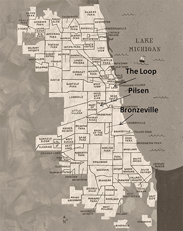
Neighborhoods are the building blocks of cities, each with distinct features and functions. Some neighborhoods are filled with historic homes and tree-lined streets, while others are bustling with high-rise apartments, shops, and offices. Residential areas often include schools, parks, and small grocery stores, creating a sense of convenience for families. In contrast, commercial neighborhoods might have a mix of restaurants, retail stores, and entertainment venues. Together, these diverse neighborhoods bring vibrancy and life to cities, offering spaces where people live, work, and socialize. Neighborhoods are the smaller areas within cities where people reside and interact. They come in many styles, ranging from historic buildings to new and modern ones. Some neighborhoods develop around groups of people who share common cultures or languages. In Chicago, for example, you’ll find neighborhoods like Chinatown, Pilsen (a Mexican-American area), and Greektown.
What’s your favorite neighborhood in the city where you live, and what makes it welcoming?
Activity 4 – What can you do in your city?
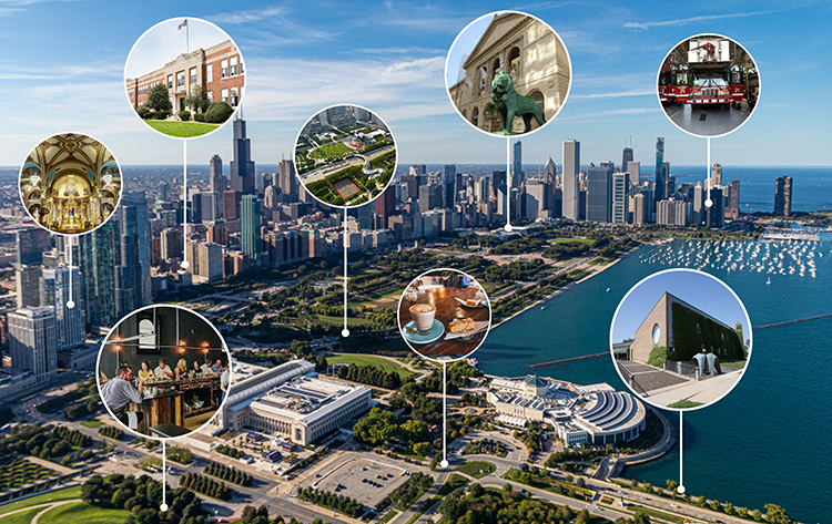
Cities are for everyone. Cities are places where everyone has the chance to reach their full potential. What is there to do in your city? Can you play in a park, or is there a place to watch a play? Can you go to museums or visit botanical gardens? Is there a zoo? Are there dog parks? Can you play basketball, soccer, tennis, or pickleball outside? Does your city have a historic city tour? City tours take you to the downtown area, share significant landmarks, and discuss the city’s culture and history. Is there a place to shop and a farmer’s market selling local produce and products? Does your city have theaters, symphonies, libraries, and more? In this exercise, make a word map of things that are fun to do in your community. Make sure to think about options in all seasons and during the day and night. Think of music performances, plays, celebrations, festivals, too! Create a city map and identify 10 destinations you’d like to visit.
What do you like to do in your city?

Activity 5 – Explore Major Cities: St. Augustine, Florida, USA
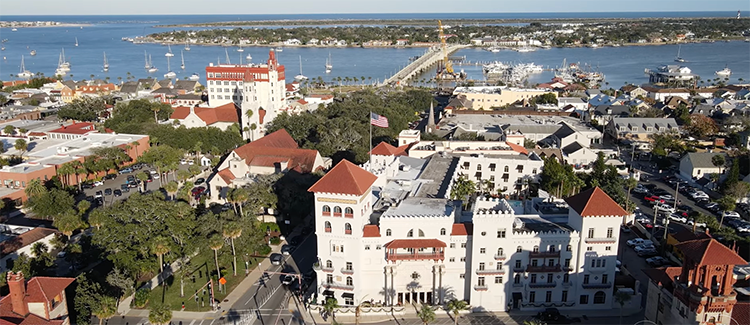
St. Augustine, founded in 1565, is the oldest city in the continental U.S. Built by Europeans, it features a central park, stone streets, Spanish-style buildings, and historic forts, such as the Castillo de San Marcos, and churches. Although the town has only about 15,000 residents, more than 6 million people visit each year to see its history. The city earns its primary income from tourism and hosts events that celebrate its Spanish, Native American, and African American heritage. The oldest street in St. Augustine, Florida, is Aviles Street, originally known as Hospital Street. It was home to the second Spanish Military Hospital, a cemetery, churches, and other important buildings. Flagler College is a thriving university in St Augustine in the historic District. Today, Aviles Street and St Augustine are a vibrant arts district with galleries, shops, and restaurants. Located on the coast, the city is planning for resilience to storms.
How can cities protect old buildings while still growing?
Activity 6 – Explore Major Cities: Santa Fe, New Mexico, USA
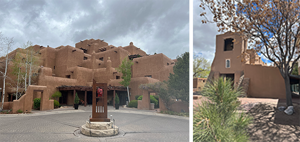
Santa Fe was founded in 1610 and is the oldest state capital in the U.S. It sits more than 7,000 feet above sea level and is known for its Pueblo-style buildings that reflect Native, Spanish, and Mexican cultures. With a population of around 89,000, it welcomes more than 1 million tourists each year. People come to see its art galleries (over 250 of them), the Santa Fe Opera, and the Georgia O’Keeffe Museum. Santa Fe has rules to protect its building style and focuses on clean energy and smart city planning.
How do art and culture make a city more interesting?
Activity 7 – Explore Major Cities : Tokyo
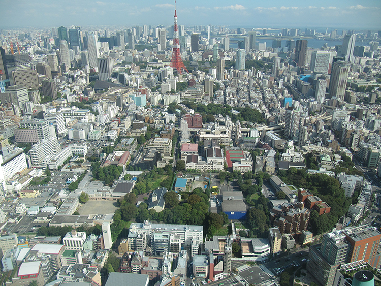
Tokyo is the capital of Japan and one of the world’s most technologically advanced cities. With a population of over 37 million in the greater metropolitan area, Tokyo is the largest and most densely populated urban area in the world. Tokyo is renowned for its blend of ancient traditions and futuristic innovations. You can find peaceful temples and shrines right next to neon-lit skyscrapers and high-speed trains. The city is immaculate and organized, with a world-class public transport system that includes bullet trains (Shinkansen). Popular districts include Shibuya, known for its famous crossing and fashion, Marunouchi, with the Imperial Palace and a business and commercial district near Tokyo Station; Nihonbashi and Akihabara are well-known for their electronics and anime culture. Tokyo hosted the Olympics in 1964 and again in 2021 (postponed from 2020).
What does Tokyo teach us about blending the old and the new? Draw or list three things about Tokyo’s culture that stand out to you. Would you rather visit a temple or a robot café in Tokyo? Why?
Activity 8 – Explore Major Cities: Paris
Paris, known as the “City of Light,” has a history of over 2000 years as a center of trade, art, culture, cuisine, education, intellectual life, and revolution. It is home to over 11 million people in its metro area. Initially settled by the Parisii, it became a Roman city, then a walled city as its population expanded. Catherine de Medici claimed riverfront land to build a new palace for the king, featuring one of the largest and oldest French-style gardens, the Tuileries. The Marais Place Royale, constructed between 1605 and 1612 under the reign of Henry IV, opened a new neighborhood with housing for the king and queen, as well as wealthy families around a jousting green. In the 1800s, Paris was ‘modernized’ by Urban Planner, Baron Haussmann, who added wide streets, parks, and improved sewer systems. Today, Paris is renowned for its fashion, cuisine, museums, and cultural world events. It is becoming greener by building more than 1,000 km of bike paths and closing 500 roads to pedestrians only. The Louvre Museum, the world’s largest art museum, is one of its top attractions. Approximately thirty million tourists visit Paris each year.
How can a city preserve its history while still growing and improving?
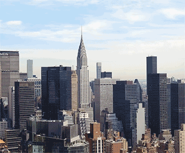
Activity 9 – Explore Major Cities: New York City
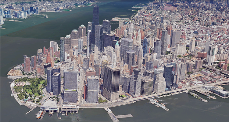
The world has changed a lot over the past 70 years. One of the most significant changes has been the rapid growth in the number and size of cities. In 1955, only a small number of cities had populations over 1 million. By 2016, there were more than 500 cities with populations exceeding 1 million!
This growth is known as urbanization, the process where more people move from rural areas (the countryside) into cities. Factors like job opportunities, education, transportation, and healthcare attract people to urban areas. While urbanization brings progress and innovation, it also creates challenges like overcrowding, pollution, and pressure on housing and services. Cities must grow wisely to remain livable and sustainable. Use a world map or a graph to compare how cities have grown between 1955 and 2016. Which regions grew the most? Why do you think more people moved to cities at that time? Imagine what cities might look like in 2200; draw or describe your vision.
Do you think cities will be larger or smaller in the future? What would your dream future city look like?
Review
- What is a key feature that contributes to a city’s uniqueness?
- What is one important role of green spaces in cities?
- Why are well-designed transportation systems important for cities?
- What is one key feature of residential neighborhoods in cities?
- What role do public buildings like libraries and hospitals play in a city?
- What is one major challenge cities face, and how are they solving it?
Explore
- 100 Resilient Cities
- 15 Minute City CNU
- Atlas of ReUrbanization
- Atlas of UrbanIzation Density Change in Global Cities
- Barcelona SUperblocks city redefined
- California Walkable City Planned
- Calthorpe China Design Manual
- Carl Sandburg's Poem About Chicago
- Center for Planning Excellence Louisiana
- Cities United Nations
- City as Living Lab Flow: Can You See The River
- City in a Garden Graphic Novel, Art of Science Learning
- City Streets (Drawn Online)
- Cityx Project
- David Brown The Available City
- DZH De Zwarte Hond Berlin, Rotterdam, Cologne
- Earth Overshoot Day Steps Cities Can Take to Offset Global Warming
- Ebeneezer Howard
- EPA Smart Growth Guidelines
- Gensler The future of the 20 minute City
- Global Platform for Sustainable Cities
- Henning Larson Henning Larsen is an architecture, landscape, urbanism design studio.
- How to Build A City From Scratch
- Interactive Nolli Map of ROME
- Italio Calvino Invisible Cities
- Jane Jacobs The Center for the Living City
- Jan Gehl
- Largest Cities Throughout History
- Manhattan's Welikia Project
- Michael Heizer's Nebraska Desert City
- Milwaukee Community Map
- NAAEE Community Engagement Guidelines Pdf
- National League of Cities
- OECD Better Life Index
- Oldest Cities in the World
- Open Cities UK
- Paris 4kDrone Footage
- Paris Coat of Arms and City logo history
- Pictures of American Cities
- Project For Public Space
- Smart Code
- Sounds in the City
- TED David MaCaulay Surprises of Rome
- TEDed Real Life Sunken Cities
- TEDed: Urbanization and the Evolution of Cities
- The Sand Pit
- The Urban Transect DPZ
- The Wacker Manual 1911
- The Young Urbanists Handbook
- United Census Megalopolis
- Urban Engineers
- Urban Network Framework for Growth
- Urban Observatory
- Urban Observatory
- Urban Population Timeline
- Video City Development
- Video Marseilles City of Neighborhoods Google Earth
- Video The Art of Building Cities
- Video The Art of Building Cities
- Video Venice in 3d Google Earth
- World Database of Large Cities 1950-2050
- World Data on Urbanziation
Relate
- 2D Geometry

- Air Quality

- Architecture

- Bike Lanes
- Biomimicry

- Bridges

- Building Types

- Bus Stop

- Concrete

- Detail

- Eating Local

- Electric Light

- Experience Design

- Facade Elements

- Farmers Markets

- Green Cities

- Green Neighborhoods

- Grid

- Historic Preservation

- Housing Styles

- HOUSING TYPES

- Land

- LAND USE

- Maps

- Mass Transit

- Modern Architecture

- Multimodal Transportation

- Nano technology

- Neighborhood

- Organization

- Parks

- People

- Place Experience

- Place Exploration

- Placemaking

- Plants

- Playscapes

- Pocket Parks

- Public Space

- Rivers

- Site Analysis

- Site Programming

- Skyscrapers

- Smart Cities

- Soundscapes

- Streets

- Sunlight

- Systems Thinking

- TIny House

- Tree Identification

- Urban Agriculture

- Urban Design

- Vernacular Architecture

- Walking

- Water

- Water Quality

- Watershed

- Wayfinding

- Wind Power


All contents copyright © NEXT.cc. All rights reserved. Terms of Use