


The story of civilization is very much made of stories of its cities. Jericho Turkey, considered to be one of the earliest organized settlement of humans, dates back to 8000 B.C.. From ancient Egypt, China and Mesopotamia to the Mediterranean world of Greece and Rome to the Mayan and the Aztecan, people are drawn to live together. Jericho Turkey, considered to be one of the earliest organized settlement of humans, dates back to 8000 B.C.. From ancient Egypt, China and Mesopotamia to the Mediterranean world of Greece and Rome to the Mayan and the Aztecan, people are drawn to come together. The story of civilization has been the story of its cities. Rapidly growing metropolises evolve into the highest forms of human social organization, yet in their complexity and constant movement, they also hold civilization’s constant failings. People of all backgrounds and income levels live, work, learn and play in cities, towns and villages. Cities consist of streets, parks, rivers and lakes, people, places and things! Cities are in constant motion, always building and rebuilding. Our cities shape the way we live in very profound ways.
A city is a place where people go and live, learn, work and play…..visit and grow up……hope and dream!
Activity 1 – See a City
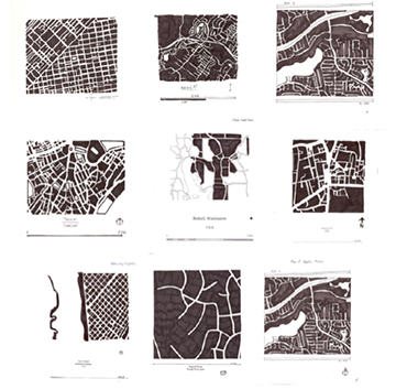
Architecture, buildings and cities, form a second skin on the earth. What kind of patterns do our cities make? Those of us who like to study maps can tell a lot about a city from looking at maps of cities. Google city maps and spend some time locating rivers in cities. See if you can locate centreville or downtown in your city. Can you read residential areas in different degrees of density? Cities are dense collections of people living, working, learning and playing, Using Google Map, take a bird’s eye view of your very own city. Print off or copy from the computer a map of your city that shows 1 mile wide by 1 mile tall. Carefully draw the different black shapes and sizes. Now color in all of the privates uses in black, leaving everything that is public white. For instance, most streets are public. Most parks are public. Public green spaces are public. Public schools are ….public! Buildings of individuals and offices rented or owned by companies are private. Draw the 1 mile by 1 mile of your city. Compare your city with two other cities. What differences can you see? What similarities are revealed? Learn to look at diversity in cities by studying patterns of development and ownership. Public and private space are both important in cities.
Activity 2 – Image Your City

Each of us is born, grows up and now lives in a place. From pictures, memories and your imagination, make a drawing comprising ideas about where you originated and/or grew up. This ‘urban self-portrait’ will communicate location, character, and imagery of where you came from.
Include a location map, block layout, important buildings in plan form and any essential views that visually portray the place in which you are living. Locate important buildings in your neighborhood such as the school, church, library, grocery store, playground, park, etc. Make a copy of your drawing and paste it in your journal.

Activity 3 – Urban Involvement
Cities are mixed used dense areas that combine places to live, work, play and learn. Many players like politicians, investors, planners, designers, developers play roles in shaping what is built and where. Citizens of cities are becoming more involved in building awareness and creating momentum for what is needed in cities. Take a look at Chideas to see how cities are connecting with citizens to improve livability. What organizations work to inform and engage residents in decision making? Research organizations working to make the city better. Make a poster about them and write a three page report.
Be involved. Imagine the future!
Activity 4 – draw your city in 10 views

Cities are constantly changing, building, tearing down and rebuilding what exists. You will dissect your city by drawing 10 different systems that come together to create the places where people work, live , play and learn. You will use maps to find the systems and can interview people in your city government to find out more about what your city has to offer. Begin this exercise with a map of your city. You can use Google Earth, Google Maps or Mapquest to deliver an aerial view. You can do all of the maps yourself or get 10 people in your class to help you. You will need tracing paper and colored pencils and access to information about your city.
1 WATERSHED: show rivers, streams, lakes, wetlands in blue. 2 PUBLIC GREENS: show all public parks and greens in green 3 TRANSIT: show the train station, train lines, bus lines in black 4 PEDESTRIAN: show side walks in yellow. 5 CULTURAL: color all cultural institutions- schools, museums, theaters, performance halls, etc. in red. 6 ARTERIES: CORRIDORS: BOULEVARDS: STREETS: ALLEYS: ALLEES; show streets in gray 7 COMMERCIAL: show commercial in orange 8 OFFICES: show offices where people work in brown 9 INDUSTRIAL: show industrial areas in beige 10 RESIDENTIAL: show single family homes, apartments and high rise residential towers in purple
Pin your map up. Present the information about each system that you have gathered. Ask the city planner to come to your class after you have made your maps and find out what plans the city has for economic development. Most cities have ideas about where they would like to expand areas or densify areas or improve areas. Urban designers study city systems and neighborhoods and suggest strategies to improve living conditions for the future.
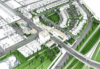
Activity 5 – design a city

The age of the automobile has contributed to our current horizontal dominance over the land. Do you need to drive everywhere to get everything you need to live? Can you work, learn, and play in your community within a 15 minute walk? There are alternatives to sprawl which recognize the specificity of place, respond to the climate, vegetation and views, and offer mutli-generational mixed income living/working/learning/leisure opportunities. It is about choice. We have a choice about what to save and what to build.
Now it is your turn to envision a new community. Make a list of the things that you think are necessary for a community. Play the Sustainability Town Game Design, in plan and in two sections, your dream community. Color code and label the different functions: Commercial, Office, Educational, Recreational, Public Greens. Open Conserved Land, Single family Homes, Duplexes, Apartments, Senior Housing. Be sure to set destination points reachable via sidewalks, bike paths and hiking trails throughout your community. Can you create a new community with a school, medical building, library, post office, grocery store, public spaces, and conserved open lands?
Activity 6 – Scales of cities

Cities exist at multiple scales, each contributing uniquely to the life and function of urban spaces. At the smallest scale, Small Cities often provide essential services with lower population densities and simpler infrastructure. Medium Cities build on this by offering a broader range of services, cultural amenities, and economic opportunities, serving as regional hubs. Large Cities, with their higher population densities and complex infrastructure systems, become centers of diverse industries, culture, and governance.
Metropolises, even larger and more influential, serve as central nodes of political, cultural, and economic power for entire regions. Beyond this, Megalopolises emerge when multiple metropolitan areas grow together, forming vast urban regions with shared infrastructure and economic interdependence.
Do you live in a city? If so, what type of city do you live in, and how does it shape your daily experiences?
Review
- Which is the oldest inhabited city in this list?
- A grid is a good way to organize a community.
- Cities shape our daily lives.
- Cities are made of:
- People move to cities to find:
Explore
- 10 Urban Diagrams
- 2070 Mega City Future World
- Art of Building Cities
- Atlas of reurbanism
- Atlas of ReUrbanization
- Cell City Analogy
- Center for Urban Pedagogy
- Charles Correa
- Chicago 2040 Scenarios
- Chicago's Burnham Plan
- Chora
- Chora Conscious City
- CLUAA Clare Lyster Urbanism and Architecture
- Collecting Local Data APP
- Cooper Robertson
- David Baker's Better Living Through Density
- De Zwarte Hond
- Digital Twins Cities & Simulations
- Doepelstrijkers Rotterdam
- Edi Rama: Take Your City Back
- Envisioning Development
- Farm From A Box
- Fly through Ancient Rome!
- GuggenHeim Lab: 100 Urban Trends
- How does a city grow?
- HyperCities
- Interactive Map of Rome: Natural, Architectural, Social, Cartography
- Interactive Nolli Map of ROME
- Machester England City in Transition
- Mayors' Institute of City Design
- My Imaginary City
- National Geographic Expedition Planning a New Town
- OECD Better Life Index
- OPEN CITY London
- PAU Architecture & Urbanism
- Reading An Urban Landscape
- Relevancy of New Urbanism in age of Climate Change
- Resource for Urban Design Information
- Rome Reborn Video
- Scenario Journal Building The Urban Forest
- Shade Lab
- SITELAB
- Smart Growth
- Squint Opera
- STOSS: Landscape Urbanism
- Tactical Urbanism Guide
- Tatiana Bilbao Estudio
- TEDed What happens if you cut down all of a city's trees? - Stefan Al
- The Available City
- The Manahatta Project
- The Nature of Cities
- The Sustainable Town Game
- The Transect
- Under New York
- UNESCO Damascus
- Unicef Interactive Urban Population Prediction
- UrbanGreenGardens NYC
- Urban Lab
- Urban Lab CH.IL.us
- Urban Lab Sarah Dunne Video
- Urban Observatory
- Urban Strategies
- Urban Trees
- Video The Best Planned City in America
- Video The Urban/Unseen
- Video When a Town Runs Dry
- Wacker Manual
- Welikia Explore Mannahatta
- What is new urbanism?
- WorldView
- Zonar by Gridics
Relate


All contents copyright © NEXT.cc. All rights reserved. Terms of Use